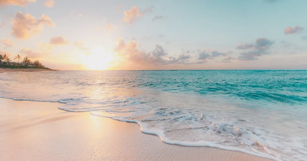
Ibiza has over 210 kilometres of coastline, and the uncomfortable truth for anyone arriving by car or bus is that the best parts of it are unreachable by road. The cliffs of the north coast, the sea caves beneath Es Vedra, the untouched sandy crescents tucked between headlands on the east — these places have no parking, no beach bars, and no footpath. The only way in is by boat.
This guide lays out four detailed sailing routes around Ibiza, each covering a different stretch of coast, each packed with hidden coves and secret beaches that most visitors never see. We include approximate GPS waypoints, distances in nautical miles, timing suggestions, and practical anchoring advice — everything you need to plan a day (or a week) of exploration on the water.
Whether you are chartering a sailboat, catamaran, or motorboat from EasyBoat, these routes work for any vessel. Adjust the pace to suit your boat's speed, your group's energy, and the wind conditions of the day.
Before You Go: Wind Patterns & General Sailing Conditions
Understanding Ibiza's wind patterns will make or break your itinerary. The island sits in the western Mediterranean, and its weather follows predictable seasonal rhythms:
- Summer thermals (June–September): A reliable sea breeze fills in most afternoons from the south-southeast at 8–15 knots. Mornings are often calm. Plan departures early and use the afternoon wind for sailing legs.
- Tramontana (north wind): A dry, sometimes gusty wind from the north that can blow 15–30 knots. When it arrives, the north coast becomes exposed and uncomfortable. Switch to the sheltered south or west coast.
- Llebeig (southwest wind): Warm and humid, common in spring and autumn. It exposes the west coast but leaves the east coast calm and inviting.
- Levante (east wind): Pushes swell into the east-facing coves. When Levante blows, head west or south.
General Anchoring Advice for Ibiza
Ibiza's seabed is a mix of sand, rock, and Posidonia oceanica seagrass meadows. Posidonia is a protected marine plant — anchoring on Posidonia is illegal and carries fines of up to EUR 300,000. Look for sandy patches (lighter-coloured seabed) and drop your anchor there. Many popular coves now have eco-mooring buoys; use them when available. Your skipper will know the designated anchoring zones, and official Posidonia maps are available from the Balearic government.
Route 1: The Wild North Coast
The north coast of Ibiza is the island's untamed side — towering cliffs, deep sea caves, pine forests running down to the waterline, and almost no development. This is where you find the most dramatic scenery and the emptiest beaches.
Itinerary Overview
| Waypoint | Location | Approx. Coordinates | Leg Distance | Suggested Time |
|---|---|---|---|---|
| Start | Port de Sant Miquel | 39.05°N, 1.44°E | — | 09:00 departure |
| 1 | Cala d'Albarca | 39.08°N, 1.39°E | 3.5 NM | 09:30 – 11:00 |
| 2 | Cala d'en Sardina | 39.07°N, 1.37°E | 1.2 NM | 11:15 – 12:00 |
| 3 | Ses Margalides Islets | 39.07°N, 1.35°E | 1.0 NM | 12:15 – 13:00 (snorkelling) |
| 4 | Cala Salada / Cala Saladeta | 38.98°N, 1.26°E | 6.5 NM | 14:00 – 16:00 (lunch & swim) |
| Return | Port de Sant Miquel or San Antonio | — | 5.0 NM | 17:00 arrival |
Total distance: approximately 17 NM. Total time: 8 hours at a relaxed pace.
Highlight: Cala d'Albarca
This is arguably the most spectacular hidden cove on the entire island. Cala d'Albarca sits beneath 100-metre cliffs on the northwest coast, with no road access whatsoever. The only way in is by boat or via a challenging 90-minute cliff hike that most people never attempt. The cove itself features a pebble beach, deep blue water, and a massive sea cave that you can swim or dinghy into. Anchor in 5–8 metres over sand just outside the cove mouth. In calm conditions, you can nose carefully into the cove itself, but keep a close eye on swell — it amplifies between the cliff walls.
Highlight: Cala Salada & Cala Saladeta
These twin coves on the northwest coast are accessible by road, but the small car park fills up by 10 AM in summer, and the beach gets packed. Arriving by boat changes the experience entirely. Anchor 50–100 metres offshore in 4–6 metres of water over sand, swim to the quieter Cala Saladeta (the smaller, northern cove), and enjoy pine-shaded rocks and crystal-clear water without the crowds. For more coves like these, see our guide to the best beaches in Ibiza accessible by boat.
Route 2: The West Coast — Es Vedra, Atlantis & Sunset Coves
The west coast is Ibiza's most iconic stretch of water. This is where Es Vedra rises 400 metres from the sea, where the legendary "Atlantis" rock formations hide beneath the cliffs, and where Cala Comte puts on the finest sunset show in the Mediterranean.
Itinerary Overview
| Waypoint | Location | Approx. Coordinates | Leg Distance | Suggested Time |
|---|---|---|---|---|
| Start | San Antonio Harbour | 38.98°N, 1.30°E | — | 10:00 departure |
| 1 | Cala Comte (Platges de Comte) | 38.96°N, 1.23°E | 4.0 NM | 10:30 – 12:00 |
| 2 | Cala Vedella | 38.93°N, 1.22°E | 2.0 NM | 12:15 – 13:30 (lunch anchor) |
| 3 | Es Vedra / Es Vedranell pass | 38.87°N, 1.21°E | 3.5 NM | 14:00 – 15:00 (sail-by & photos) |
| 4 | Atlantis (Sa Pedrera de Cala d'Hort) | 38.88°N, 1.22°E | 0.5 NM | 15:15 – 16:30 (swim & explore) |
| 5 | Cala d'Hort | 38.89°N, 1.23°E | 0.5 NM | 16:45 – 17:30 |
| Return | Cala Comte for sunset, then San Antonio | — | 6.0 NM | 18:00 – 21:00 |
Total distance: approximately 16.5 NM. Total time: 10–11 hours (this is a long, full-day route best suited to sunset charters or extended bookings).
Highlight: Es Vedra
No sailing trip around Ibiza is complete without seeing Es Vedra from the water. This limestone monolith rises dramatically from the sea off the southwest coast, shrouded in local myths about magnetic anomalies and UFO sightings. Landing on Es Vedra is prohibited (it is a protected nature reserve), but sailing between Es Vedra and the smaller Es Vedranell islet is a breathtaking experience. The channel between them is roughly 200 metres wide with deep water — safe for any vessel, but watch for strong currents on windy days. Dolphins are frequently spotted in this area.
Highlight: Atlantis (Sa Pedrera)
Atlantis is one of Ibiza's best-kept secrets. Hidden beneath the cliffs south of Cala d'Hort, this former quarry site features otherworldly rock formations carved by centuries of stone cutting and erosion — natural pools, carved faces, flat platforms, and tidal channels that create a landscape unlike anything else on the island. By land, it requires a 40-minute scramble down an unmarked cliff trail. By boat, you simply anchor offshore and swim in. The water is deep right up to the rocks, so approach carefully and anchor in 6–10 metres over sand northwest of the site. This spot is only accessible in calm conditions — any swell makes the rocks dangerous.
For more unforgettable evening experiences on the water, explore our guide to sunset cruises in Ibiza.
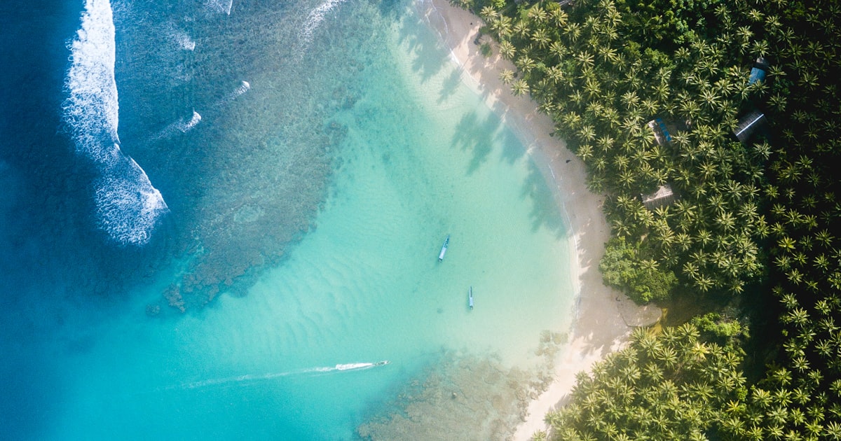
Route 3: South Coast & Formentera — Caribbean Waters
The crossing from Ibiza to Formentera is the island's most popular day trip by boat, and for good reason. Formentera's beaches regularly feature on "best in Europe" lists, and the shallow strait between the two islands — Es Freus — has water so turquoise it looks digitally enhanced. But most charter boats go straight to Ses Illetes and back. This route takes you to the places they skip.
Itinerary Overview
| Waypoint | Location | Approx. Coordinates | Leg Distance | Suggested Time |
|---|---|---|---|---|
| Start | Marina Botafoch, Ibiza Town | 38.91°N, 1.45°E | — | 09:00 departure |
| 1 | Cala Jondal | 38.87°N, 1.38°E | 5.0 NM | 09:45 – 10:30 (quick swim) |
| 2 | S'Espalmador (north beach) | 38.80°N, 1.42°E | 5.5 NM | 11:15 – 13:00 (beach & mud bath) |
| 3 | Ses Illetes, Formentera | 38.77°N, 1.43°E | 1.5 NM | 13:15 – 15:00 (lunch anchor) |
| 4 | Es Calo de Sant Agusti (east Formentera) | 38.73°N, 1.50°E | 5.0 NM | 15:30 – 16:30 (optional, for longer charters) |
| Return | Cross Es Freus strait back to Ibiza Town | — | 8.0 NM | 17:00 – 18:30 |
Total distance: approximately 25 NM (or 17 NM without the Es Calo detour). Total time: 9–10 hours full route, 7–8 hours shortened.
Highlight: S'Espalmador
S'Espalmador is an uninhabited island lying between Ibiza and Formentera. It is privately owned but publicly accessible, and it feels like stepping onto a desert island. The northern beach is a long, white-sand crescent with shallow turquoise water that rarely has more than a handful of boats anchored nearby. On the island's interior, you will find a natural mud pool — locals claim the mineral-rich mud has therapeutic properties. Anchor in 2–3 metres over sand on the north side. Beware of the shallow sandbar extending east from the island — approach from the north or west and keep an eye on your depth sounder.
Highlight: Es Freus Strait
The channel between Ibiza and Formentera is dotted with small islets and rocky outcrops. Currents can run at 2–3 knots through the narrower passages, and the seabed shelves from 20+ metres to 2 metres very quickly in places. Stick to the marked navigation channel if you are on a deeper-draft vessel. For shallow-draft boats and catamarans, the passage between the islets offers spectacular turquoise water over white sand — some of the most photogenic water in the entire Mediterranean.
If you are renting a boat without a license, note that the Formentera crossing is not permitted for small no-license boats. You will need a skippered charter or a licensed vessel of appropriate size for open-water passages.
Route 4: The East Coast — Quiet Bays & Tagomago Island
The east coast of Ibiza is the least-visited by charter boats, which is exactly why you should go there. While everyone heads west for Es Vedra or south for Formentera, the eastern shore offers sheltered bays, excellent snorkelling, and the exclusive Tagomago Island.
Itinerary Overview
| Waypoint | Location | Approx. Coordinates | Leg Distance | Suggested Time |
|---|---|---|---|---|
| Start | Santa Eulalia Marina | 38.98°N, 1.54°E | — | 09:30 departure |
| 1 | Cala Llonga | 38.96°N, 1.55°E | 1.5 NM | 10:00 – 10:45 |
| 2 | Cala Pada / Sol d'en Serra | 38.98°N, 1.57°E | 2.0 NM | 11:00 – 12:00 (snorkelling) |
| 3 | Tagomago Island (west side) | 39.03°N, 1.65°E | 5.0 NM | 12:45 – 14:30 (circumnavigation & lunch) |
| 4 | Cala de Sant Vicent | 39.08°N, 1.58°E | 4.5 NM | 15:00 – 16:30 (swim & relax) |
| 5 | Cala Xarraca | 39.10°N, 1.54°E | 2.5 NM | 17:00 – 18:00 |
| Return | Santa Eulalia Marina | — | 8.0 NM | 18:00 – 19:30 |
Total distance: approximately 23.5 NM. Total time: 9–10 hours. This is an ambitious full-day route; shorten it by skipping Cala Xarraca and returning directly from Cala de Sant Vicent (saves roughly 10 NM and 2 hours).
Highlight: Tagomago Island
Tagomago is a small private island off Ibiza's northeast tip. You cannot land without permission (the island has an exclusive villa that rents for five figures per night), but you can circumnavigate it by boat. The west side is sheltered from prevailing winds and offers a stunning anchorage over a sandy seabed in 5–8 metres of water. The underwater visibility here is often 20+ metres, making it one of the best snorkelling spots accessible by boat. Keep an eye out for grouper, octopus, and barracuda.
Highlight: Cala Xarraca
Tucked into the northeast coast, Cala Xarraca is a horseshoe-shaped bay with warm, shallow water and a pebbly seabed that is perfect for anchoring. The surrounding rocky coastline is riddled with small inlets and swim-throughs. There is a small chiringuito (beach bar) ashore if you want to stretch your legs. In the late afternoon, the bay catches golden light that turns the water an extraordinary shade of emerald green. Anchor in 3–5 metres over sand, well clear of the Posidonia patches that fringe both sides of the bay.
Choosing the Right Route for Your Trip
Not sure which route to pick? Here is a quick comparison to help you decide:
| Route | Best For | Distance | Difficulty | Best Wind Conditions |
|---|---|---|---|---|
| North Coast | Adventure seekers, photographers, nature lovers | 17 NM | Moderate | South or light winds |
| West Coast | Iconic landmarks, sunset chasers, couples | 16.5 NM | Easy–Moderate | East or light winds |
| South / Formentera | Beach lovers, families, first-time visitors | 17–25 NM | Easy (open crossing) | Any light-moderate winds |
| East Coast | Snorkellers, solitude seekers, experienced sailors | 23.5 NM | Moderate–Challenging | West or light winds |
Your skipper can combine sections of different routes, too. A popular half-day option is to take the first two stops of the West Coast route (Cala Comte + Cala Vedella) and return — roughly 8 NM and 5 hours. Another favourite is the shortened Formentera run: straight to S'Espalmador, lunch at Ses Illetes, and back — about 15 NM and 6–7 hours.
Practical Sailing Tips for Ibiza
Whether you are a seasoned sailor or a first-time charterer, these tips will make your Ibiza sailing experience smoother and safer:
Timing Your Day
- Depart early (09:00–10:00). Mornings are calm, anchorages are empty, and you beat the day-charter crowds that leave marinas at 11:00–12:00.
- Anchor for lunch between 12:00–14:00. The midday sun is fierce — find a sheltered cove, deploy a shade canopy, and swim before eating.
- Plan your last anchor stop by 16:00–17:00. This gives you time to enjoy the late-afternoon golden light before heading back or repositioning for sunset.
- Sunset is the grand finale. Position your boat facing west by 20:00 (July/August) or 18:30 (May/October). Cala Comte, the waters off Es Vedra, and the bay of San Antonio all offer world-class sunset views.
Anchoring Best Practices
- Always check the seabed before dropping anchor. Sandy patches appear as light, bright areas on the water; dark patches are Posidonia or rock.
- Use a scope of 5:1 (five metres of chain for every one metre of depth) in calm conditions, and 7:1 if the wind picks up.
- Set the anchor by reversing gently and checking that the GPS position holds steady for 2–3 minutes.
- In popular coves during July and August, arrive before 11:00 or after 15:00 to find space. Midday is peak crowding.
- Keep a VHF radio on channel 16 and monitor local notices. Ibiza port authorities occasionally close anchorages for environmental protection or military exercises.
Safety Essentials
- Carry more water than you think you need — at least 2 litres per person per half day.
- Apply reef-safe sunscreen every 2 hours. Sun reflection off the water doubles UV exposure.
- If renting without a skipper, ensure you know the location of the nearest port of refuge on your route in case weather deteriorates.
- Watch for swimmers when approaching coves under engine — reduce speed to under 3 knots within 200 metres of any beach, and within designated swimming zones.
When to Sail Each Route
Ibiza's charter season runs from April through October, but each route has its sweet spot:
- North Coast: Best in June and September, when the sea is calm but the summer thermals have not yet built to full strength. Avoid during Tramontana episodes.
- West Coast: A year-round classic, but the Es Vedra sunset is most dramatic in July and August when the sun sets at its most northerly point, lighting up the rock face in gold and orange.
- South / Formentera: Peak season (July–August) delivers the warmest water and most vivid colours, but the strait gets crowded. For tranquility, go in May, early June, or late September. Read our best time to visit Ibiza for sailing guide for a detailed month-by-month breakdown.
- East Coast: Excellent from May through October. The east side is sheltered from the prevailing summer thermals, making it the calmest water on the island most afternoons.
What Boat Should You Choose?
The right vessel depends on your route, your group, and your budget:
- Sailboat (30–45 ft): Perfect for the North and East Coast routes where the sailing itself is part of the experience. Low fuel costs, romantic atmosphere, and access to shallow coves. Requires a skipper or valid license.
- Catamaran (38–50 ft): Ideal for the Formentera route and families. Stable, spacious, and able to anchor in very shallow water. The best all-round option for groups of 8–15. See our catamaran rental guide for details.
- Motorboat (6–10 m): Best for the West Coast route if you want to cover ground quickly and visit multiple coves in a half day. Higher fuel costs but maximum flexibility.
- No-license boat (under 4 m): Suitable for short hops along the East Coast — Cala Llonga to Sol d'en Serra, for example. Not recommended for open-water routes or long distances. Learn more in our no-license boat rental guide.
Browse all available vessels on our boat listings page, or check our curated experiences for pre-planned route packages with skipper included.
Ready to Explore Ibiza's Hidden Coastline?
Find the perfect boat for your route — sailboats, catamarans, motorboats, and no-license options across all Ibiza marinas. Compare prices, check availability, and book in minutes.
Browse Boats & Book NowCombining Routes: Multi-Day Sailing Itineraries
If you have the time and the boat, combining two or more of these routes into a multi-day itinerary is the ultimate way to experience Ibiza. Here is a suggested 3-day plan:
- Day 1 — West Coast: Depart San Antonio, sail the Es Vedra route, overnight anchor in Cala Vedella or return to San Antonio.
- Day 2 — South to Formentera: Motor or sail to Formentera, spend the day at S'Espalmador and Ses Illetes, overnight at La Savina marina or anchor off the north coast of Formentera.
- Day 3 — East Coast return: Cross from Formentera to Ibiza's east coast, visit Tagomago Island, and finish in Santa Eulalia or Ibiza Town.
Multi-day charters typically come with a 10–20% discount compared to daily rates. Check our listings for boats available for multi-day hire, and filter by "overnight" capability to see vessels with cabin accommodation.
Local Knowledge: Spots Only Sailors Know
Beyond the four main routes, here are a few bonus spots that rarely appear in guidebooks:
- Punta Galera (west of San Antonio) — Flat, layered rock shelves perfect for cliff jumping and sunbathing. No beach, no sand, just smooth stone platforms into deep, clear water. Anchor 30 metres offshore in 6–8 metres.
- Es Portitxol (north coast) — A tiny inlet between Portinatx and Cala Xarraca, barely 15 metres wide. Only accessible by small boat or kayak. The water inside is emerald green and dead calm even when the open sea is choppy.
- Illa des Bosc (off Cala Comte) — The small island opposite Cala Comte has a hidden rocky cove on its eastern side. Anchor between the island and the mainland for sheltered, crystal-clear water that most boats sail right past.
- Cala Llentrisca (south coast) — A narrow, fjord-like inlet near Es Cubells. Steep cliffs on both sides, deep water, and total privacy. No road access. Anchor in the centre of the inlet in 4–6 metres.
Frequently Asked Questions
Do I need a license to sail these routes in Ibiza?
For boats over 4 metres or with engines over 15 HP, yes — you need a valid boating license recognised in Spain (PER, PNB, or equivalent EU certificate) or you must hire a licensed skipper. Small no-license boats (under 4 m, under 15 HP) can be driven by anyone over 18, but they are only suitable for short coastal hops, not the full routes described here. Most charter companies include a professional skipper in the price. See our no-license boat guide for details.
How far in advance should I book a charter for these routes?
For July and August, book at least 4–8 weeks in advance — popular boats and skippers sell out fast. For June and September, 2–3 weeks is usually sufficient. In May and October, you can often book just a few days ahead. For the best selection and early-bird pricing, browse our boat listings as soon as you know your travel dates.
Can I anchor anywhere I want around Ibiza?
No. Anchoring is prohibited over Posidonia seagrass meadows (fines up to EUR 300,000), in designated swimming zones, within port areas, and in certain nature reserves. Many popular coves now have eco-mooring buoys that you must use instead of dropping your own anchor. Your skipper will know the current regulations, and you can check the official Posidonia maps published by the Balearic Islands government before your trip.
What happens if the weather is too rough for my chosen route?
A good skipper will always have a Plan B. If the north coast is exposed by Tramontana winds, switch to the sheltered south or west coast. If Levante wind pushes swell into the east, head west instead. Most charter operators allow free rescheduling if conditions are genuinely unsafe. The beauty of Ibiza is that at least one coastline is sheltered regardless of wind direction — there is always somewhere to sail.
Is it safe to swim into the sea caves at Cala d'Albarca?
In calm conditions (flat sea, no swell), swimming into the main cave at Cala d'Albarca is generally safe for confident swimmers. The cave entrance is wide and the interior has a small pebble beach. However, if there is any swell — even a light one — waves amplify inside the cave and can be dangerous. Never enter if conditions are anything less than flat calm, and always leave someone on the boat to monitor conditions. Wearing a snorkel and fins is strongly recommended.
How much does a full-day charter for these routes cost?
A skippered motorboat (7–8 m) for a full day costs EUR 500–1,000 depending on season. A sailing catamaran (40–45 ft) with skipper runs EUR 1,200–3,000. Prices include the skipper but usually exclude fuel and catering. For a full cost breakdown by boat type and season, see our Ibiza yacht charter prices guide. You can compare real-time prices across all operators on our boat listings page.
Can I do the Formentera route in a half day?
It is technically possible with a fast motorboat — the crossing takes 20–30 minutes each way at speed — but you will feel rushed. A proper Formentera day trip needs at least 7 hours to enjoy the beaches and anchorages without hurrying. If you only have a half day, consider the shortened West Coast route (Cala Comte + Cala Vedella) or a short East Coast hop instead.